


Did you know that the map used in most schools in the United States and elsewhere around the world is inaccurate?
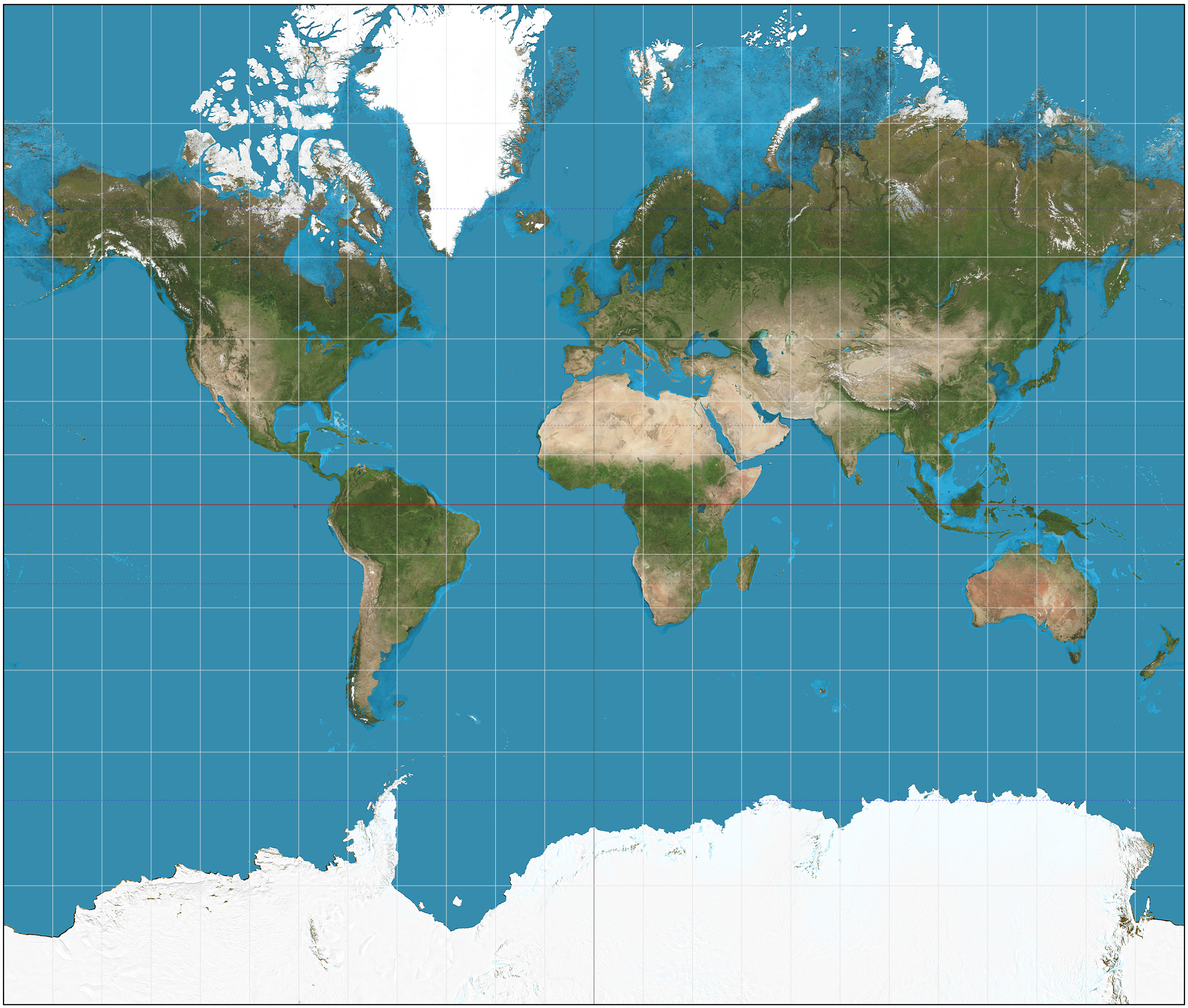
The map that’s most often used is called the Mercator Map. It distorts the size of land masses as the latitude increases from the Equator to the poles. The Mercator Map shows Greenland as being bigger than Africa. In reality, Africa has 14 times the land mass of Greenland. That’s 14 times larger! You can see how big Greenland looks on the Mercator Map below (it’s the large white land mass at the top of the map, east of Canada)…
The Gall-Peters Map tries to eliminate these inaccuracies. It makes land masses of equal size on earth look equal in size on the map. You can see how large Africa actually is on the map below (compare it to the map above)…

Boston Public Schools is the first in the US to adopt the more accurate Gall-Peters Map (they’re already used in most British schools). This trend is important because it helps to teach students what the world it actually like.
-Mama Lisa
*****
Map Credits:
Mercator Projection by Strebe
Galls-Peters Projection by Strebe
This article was posted on Friday, April 7th, 2017 at 8:04 pm and is filed under Countries & Cultures, Geography, Mama Lisa, Maps, Teaching, USA. You can follow any responses to this entry through the RSS 2.0 feed. You can skip to the end and leave a response. Pinging is currently not allowed.


April 17th, 2017 at 5:35 pm
It’s why it’s good to have also an inflatable world globe. It’s quite cheap, the proportions are more accurate and it makes it obvious that no country or continent is the center of the world.
April 17th, 2017 at 6:44 pm
We always had a globe like that when my kids were little.
Here’s a link of maps that show different perspectives. I love the one that’s totally upside-down, where north is on the bottom and south on top. Very interesting!
April 18th, 2017 at 7:00 pm
A technical detail. The only accurate map of the earth is a sphere. That makes a globe an important teaching tool. Some compromise must be made when you attempt to flatten the globe onto a flat piece of paper. Imagine cutting a plastic blow-up map into curved pieces and trying to glue them on a flat project board. (I tried this as a kid and learned something from it.) You have to squish and stretch something. Neither of these projections are more or less accurate than the other. It is just that each projection sacrifices something different. Gall-Peters sacrifices shape and angles to get the relative area right. It is far from clear that it is the best however. There are several similar projections with slightly different compromises which try to solve the same problem. Gall-Peters is becoming the consensus choice though. It is a definitely better compromise than Mercator for a teaching map. Mercator is not “wrong” but it is confusing if you don’t understand the compromise. It’s strength is that it preserves angles which Gall-Peters does not. That makes it better for navigation which is why it has been around so long.
April 18th, 2017 at 8:40 pm
Which map do you prefer?
April 18th, 2017 at 10:13 pm
Actually my favorite map of all for exploring is Google Earth, especially the app. It is very much like wandering around in a spaceship and looking down from whatever distance you want, from as far away as the moon to as close as a couple of hundred feet. You can look down or sideways or at different angles, get close or back off. It is easy to hop around and get a good perspective on things geographically. Since my first airplane flight I’ve also been fascinated by how the earth really looks from close to the ground which is not at all what maps show you. The things under the plane are close and big. The horizon is far away and things are tiny. It is hard to look at a map at the same time and connect to the same things you see out the window. When approaching or leaving Logan I try to understand where everything is outside those little windows. Yu’ve got to be quick. Sometimes you can almost see the entire Cape if you can only understand how it is all distorted and squished around. Google Earth is the only “map” that comes even close to this point of view. However it still FIXES things making close things and far things seem closer to the same size. Much like Gaal-Peters projection does come to think of it. I’ve sailed these waters a lot and looking at the shore and comparing what I see to the “charts” is always interesting, much like a bug walking on the map. Sailing is why I get the navigation perspective of Mercator. I love all your songs! Nice site. I’ve just started to explore it.
April 19th, 2017 at 4:28 pm
Thanks! That’s interesting. Google Earth just announced some major changes. Check out the article about the new Google Earth on their blog.
April 20th, 2017 at 2:34 pm
Thanks for the tip. I didn’t know about the Google maps update so I haven’t tried it yet.
Another map projection I like is polyhedral projections. The idea is that you approximate a sphere with a regular polyhedron (tetrahedron, cube all the way up to a truncated icosahedron which is the shape of a soccer ball. I forget when kids learn them.) and project the map onto that. I like polyhedral projections because you can easily create a globe with them. Polyhedra are made of flat pieces. You can print out the various parts then fold and glue them together to make your own globe. If you have it setup in advance (capture all the images from the web and put them into a document for printing) it is something kids can do. Here’s a picture of a flattened out regular dodecahedron projection of the earth. http://www.progonos.com/furuti/MapProj/Normal/ProjPoly/Img/mp_DodGnomonic-s75-z10.png
That kind of hands on experience is great for kids especially if it is done as a cross subject project along with the teaching of regular polygons in math class. Map projections are very mathematical but this kind of construction can give a good intuition of what a map projection means and why it has to be done. I had fun teaching this stuff to my kids. The youngest is about to graduate with a degree in physics and a math minor so I think it was useful. He is also the one I always sang to when he was young. I think both experiences contributed. ;-)
April 30th, 2017 at 3:44 am
In Australia and New Zealand do they have upside down maps and globes and does water really go down the plughole the opposite way?
June 5th, 2017 at 7:26 pm
Simon – I lived in NZ for 5 months and one of my jobs was to put up a wallpaper map. The map we purchased put North at the “top,” but since the option was present my employer did request I put the Pacific in the middle rather than the Atlantic Ocean. I forgot to check the water direction but apparently yes.